


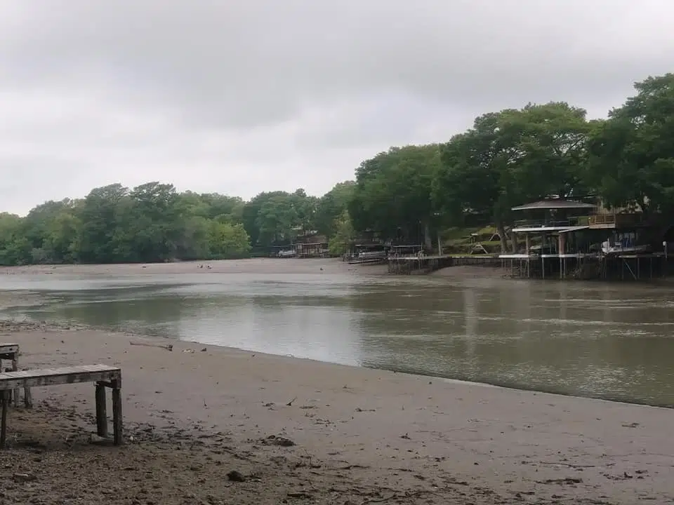
(Seguin) — The findings of a study, launched several months ago to determine the potential impact that the threat of dewatering area lakes could have on properties along the Guadalupe River, have finally been released. Those findings are found in a 100 page document supplied to the Guadalupe Appraisal District by Patrick Brown of Real Estate Consultant, Incorporated.
New Chief Appraiser Peter Snaddon says it’s been seven months since former Chief Appraiser Jaime Osborne first announced that her office was ordering this study. The purpose of the study was to look at the market value changes for the lakefront land and improved properties located along the Guadalupe River in Guadalupe County over the next four years. The subject properties, more specifically include lakes Dunlap, McQueeney, Meadow and Placid.
Snaddon says the report indicates a potential overall decrease of 28 percent for properties located along the river and its hydroelectric lakes. Snaddon says the study doesn’t mean that all property values in that area will automatically be lowered by that amount. Instead, he says it only illustrates the potential risk that exist for every case.
“Initially, the study was specifically going to be for the (Lake) Dunlap (area). When the dam failed, the spill gate there and obviously that whole area was dewatered, but then of course in August, there was the issue with potential dewatering of the other lakes. So we expanded the scope at that time to include those areas to try to determine the potential for external obsolescence, which is value lost, associated with perimeters outside the boundaries of the property itself. As a property owner, you can’t do anything about it. It’s just in the marketplace — perceptions and the risks that is involved with choosing to pay for a property that is located along those rivers,” said Snaddon.
What is yet to be determined is the sales activity for these water properties. Snaddon says the level of properties exchanging hands will, of course, vary along the river and lake areas — allowing his office to pinpoint even more how a particular property will be impacted.
“There is still movement. The activity isn’t as high as it was obviously, but there is definitely activity out there and in some areas, we’ve seen where there are some discounts being made. But there are other areas where we haven’t seen that discount, and again, it just kind of depends where you are at along that river,” said Snaddon.
“But then, we are going to get into the rest of the reappraisal process which is sales within those specific lake areas Dunlap, McQueeney, Meadow Lake, Placid and as we review, there may be some activity in those areas that show sure that perception is there but maybe, it’s not as heavy and that was shown in his report. You can see the spectrum of potential loss. He came to the average. The average was roughly about 28 percent in that first year, but of course, the spectrum was on either side of that obviously. So, you can see in some lakes, it may not be as strong as 28 percent once we look (at) sales activity and make some adjustments based off of that.”
Snaddon says since the study was first launched and announced, numerous things have already gone into play, hopefully helping to stabilize or even in some cases provide optimism for property owners around the threatened lakes.
“There’s limited sales obviously, but when you try to outline sales that happened before as well as sales that took place after — to kind of measure that potential loss that was associated with those events — this is just one tool in the appraisal process. External obsolescence, there’s physical obsolescences, there’s functional obsolescences associated with appraising, and in this case, this was just a scope that was trying to identify the potential external (obsolescence) and with that factor, we can utilize that in our process and then along with everything else that goes into appraising additional sales, because I believe you are going to see up and down that river, a different level of buyer and seller activity — people that might be willing to take that risk further down the river because they still see the water and things of that nature and they know that there has been some discussions on rectifying the issue with the spill gates,” said Snaddon.
Part of rectifying this issue has reportedly been the creation of a water control and improvement district (WCID) at least for Lake McQueeney. The WCID would be McQueeney residents’ way of taxing themselves to raise money for the replacement/repair of the dam. Residents along lakes Dunlap, Placid and Meadow have also discussed creating their own WCID. In addition, both the property owners and GBRA are set to return for a court date in October should they not reach an agreement.
Snaddon says the study projects potential loss in values through Jan. 1, 2024. He says they could only measure based on the risk as it exist today. There are still a number of factors that could come into play.
“Our appraisal date every year is January 1. So whatever conditions are present as of January 1 of every calendar year is what we are appraising to. So, a lot of times, the protest season doesn’t begin until mid-April through June and some things take place obviously during those periods of time, and they think that, that’s kind of where we need to be but essentially we are looking at the first of every year and trying to determine an opinion of value at that particular time. But yes, Mr. Brown had indicated his thoughts, his conclusions where, that he would still see somewhat of a decline overall because things are still unknown. But he felt, after the voting activity that is going to take place as well as once the risk is removed because people are aware of what will be done to hopefully solve the issues that are currently abound — that things will start moving. He felt essentially that there was going to be roughly still about two percent potential loss over the next year. So theoretically as of 2021, instead of 28, you will be looking roughly at 30 (percent) but then after that, he felt that things were going to start coming back at about a 10 percent clip,” said Snaddon.
Snaddon says it is important that the study be made available to the public, so that property owners can delve more into their specific homestead. He says transparency is and will be key throughout this entire process.
“Ideally, if they are interested in exactly what Mr. Brown concluded, a redacted copy obviously for the public consumption is on there (on the appraisal district’s website). You won’t see any pictures or any identifiable facts, but you will see figures and of course it’s methodology about coming to the figures that he arrived at. But one of the disclaimers that we put on there, was the fact that in no way, should a reader of this report conclude that the market value of any property that falls within the scope of the study, has simply decreased by the annual factors noted. The actions of buyers and sellers along these outlined areas of the Guadalupe River will vary, and (we) will incorporate all data available during our 2020 reappraisal process in accordance with the property tax code of Section 23.01,” said Snaddon.
During its initial announcement behind the study, appraisal district officials stated that what had occurred on Lake Dunlap and what was threatening other lakes were “non-typical” events for their office, making the study even more important. The lake study can be found under the press release tab at guadalupead.org.